بــرلين .. ومخبأ هتلر الذي إنتحر فيه .. وغيره من المباني
تكملة ، لما ينشر من سطور وصور عن "المرحلة النازية" في تاريخ ألمانيا الحديث ، فيما يلي ، بهص الصور والسطور الأنجليزية عن بــرلين .. ومخبأ هتلر الذي إنتحر فيه .. وغيره من المباني
ويلاحظ ، كيف أن الألمان يطمسون كل ما يمت إلي تاريخهم في هذه الفترة
د. يحي الشاعر
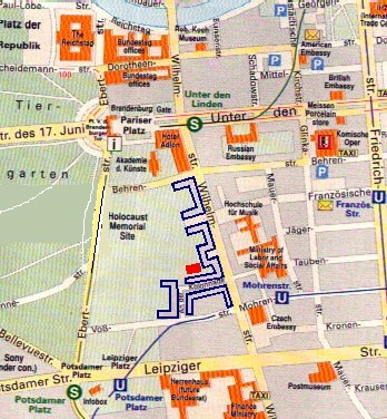
Berlin
This page will feature only a few of the sites associated with the capital of the Third Reich. Those wishing further information should consult After the Battle's Berlin Then and Now, by Tony Le Tissier (London: Battle of Britain Prints, 1997 edition).
Click here for a MapQuest map link to Berlin. Click here to visit a page about the 1936 Berlin Olympics and the Olympic grounds today.
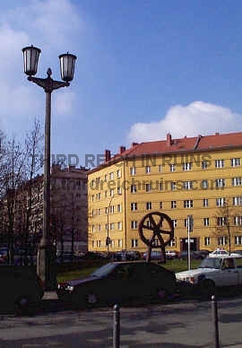
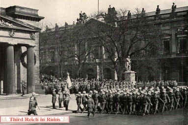
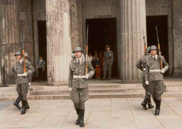
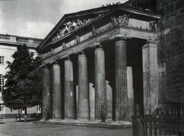
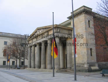
ألفت النظر إلي ، "الصورة الثانية" .. وهي لمقر ضريح الجندي المجهول .. الذي كان يقوم علي حراسته "جنود من ألمانيا الديموقراطية" ، نظرا لتواجده في برلين الشرقية ... شارع أنتر دين ليندين Unter den Linden Allee
ويلاحظ في الصورة الأولي ،كيف كان جنود "الجيش النازي" .... يمرون أمام الضريح في شكل إستعراضي ...
ويذكر المؤرخ الأمـــريــكي ، أنهم من "المنســـا"
Two different armies at the Neue Wache. On the left, Austrian soldiers parade following the Anschluك of March 1938 (the Berlin Arsenal (Zeughaus) appears in the background). On the right, East German honor guards keep watch in the 1980s. (photo on left from Gerd Rühle, ed., "Das Dritte Reich," Berlin, 1938 ed. (author's collection); photo on right courtesy R. Fogt).
On the left is the ceremonial guard from the 1st Company of Hitler's bodyguard Leibstandarte at the Neue Wache. (Hans Quassowski, ed., "Zwِlf Jahre: 1.Kompanie SS Adolf Hitler," Rosenheim, Deutsche Verlagsgesellschaft, 1989). For another period photo of the Neue Wache, see http://www.silentwall.com/SceneryBuildings66.html.
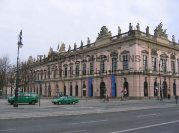
The Zeughaus (Arsenal) now houses the German Historical Museum (for more info see http://www.dhm.de/ENGLISH/zeu_hist.html). (Hans Quassowski, ed., "Zwِlf Jahre: 1.Kompanie SS Adolf Hitler," Rosenheim, Deutsche Verlagsgesellschaft, 1989)
German Pzkw. I tanks parade down Unter den Linden during a visit by Admiral Miklَs Horthy, leader of Hungary, on 25 August 1938. The Neue Wache and the Zeughaus can be seen in the right background. (Gerd Rühle, ed., "Das Dritte Reich," Berlin, 1938 ed.)
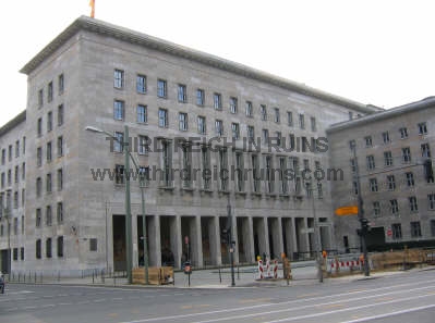
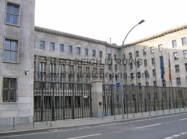
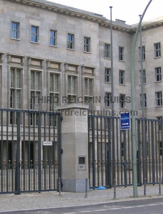
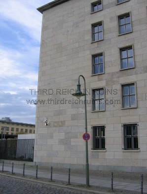
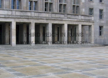
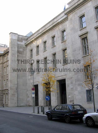
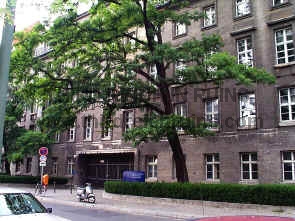
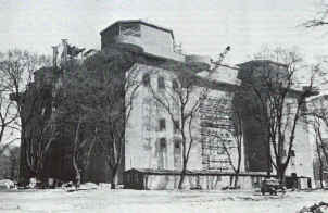
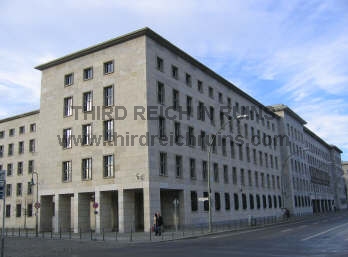
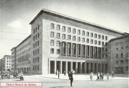
Reichsmarschall Hermann Gِring's Air Ministry building on Wilhelmstraكe was a classic example of Nazi architecture. The building somehow escaped major damage during the war, and was restored by the East German government. Its appearance today is almost exactly as in the 1930s (minus the Eagles and Swastikas). (period postcard)
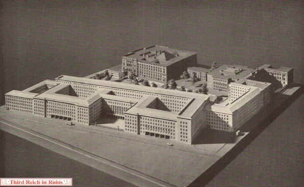
Architectural model of the Air Ministry complex. (from Official Catalog of the 1st German Architecture and Crafts Exhibition, in the Haus der Deutschen Kunst in Munich, January-March 1938 (author's collection)
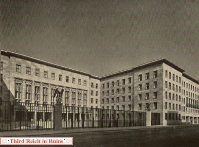
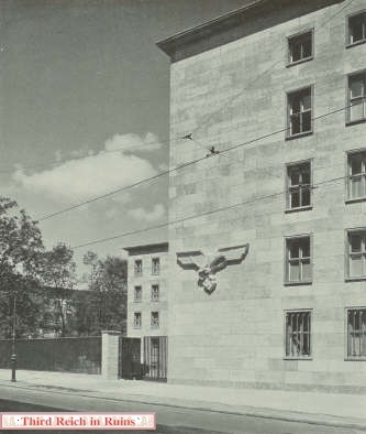
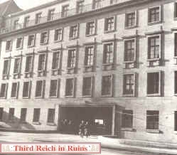
View of the Luftfahrtsministerium at the corner of Wilhelmstraكe and Prinz-Albrecht-Straكe (Niederkirchnerstraكe today). (from Hubert Schrade, "Bauten des Dritten Reiches," Leipzig, 1937)
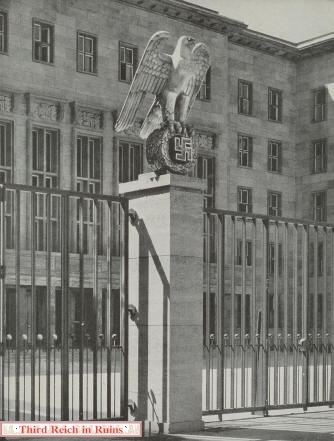
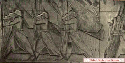
The large eagle-and-swastika Hoheitszeichen were by sculptor Walter Lemcke. Lemke also did the large eagle at the Prinz-Albrecht-Straكe side of the building (bottom). (top and bottom from Werner Rittich, "Architektur und Bauplastik der Gegenwart," Berlin, 1938; below from "Deutsches Volk - Deutsche Heimat," Munich, 1940)
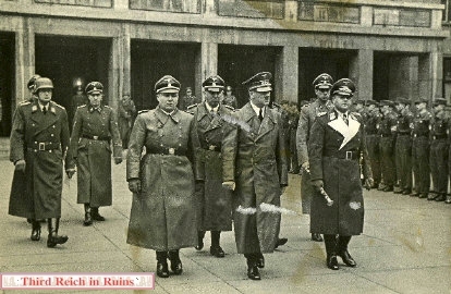
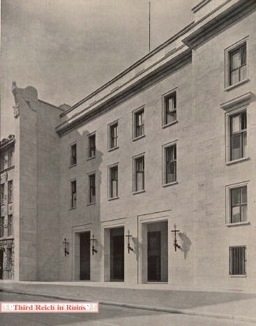
The recessed entryway on Wilhelmstraكe seen in the photos above figured in the funeral service for Luftwaffe ace Werner Mِlders, who had died in an air crash in November 1941. Seen in the center of this photo are, left to right - Martin Bormann, Julius Schaub, Adolf Hitler, Dr. Karl Brandt, and Field Marshall Erhard Milch. (period photo)
This page will feature only a few of the sites associated with the capital of the Third Reich. Those wishing further information should consult After the Battle's Berlin Then and Now, by Tony Le Tissier (London: Battle of Britain Prints, 1997 edition).
Click here for a MapQuest map link to Berlin. Click here to visit a page about the 1936 Berlin Olympics and the Olympic grounds today.
The recessed entryway on Wilhelmstraكe seen in the photos above figured in the funeral service for Luftwaffe ace Werner Mِlders, who had died in an air crash in November 1941. Seen in the center of this photo are, left to right - Martin Bormann, Julius Schaub, Adolf Hitler, Dr. Karl Brandt, and Field Marshall Erhard Milch. (period photo)
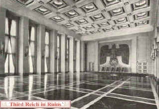
The ornate Ehrensaal, or Honor Hall, of the Air Ministry. (from "Kunst in Deutschen Reich") Other decorative sculptures in the Air Ministry Building were by Arnold Waldschmidt. (from Werner Rittich, "Architektur und Bauplastik der Gegenwart," Berlin, 1938)
Joseph Goebbels' Ministry of Propaganda stood prominently on Wilhelmstraكe, across the street from the old Reichs Chancellery. During building construction just before the fall of the Berlin Wall in 1989, a dreary East German building was erected in the open area just on Wilhelmstraكe, blocking the front of the old Ministry building. This modern building is today a youth activities building, and access to the old Propaganda Ministry building behind it can be difficult. However, the entrance shown here was on Mauerstraكe. (from Frau Prof. Gerdy Troost, "Das Bauen in Neuen Reich," Bayreuth, 1938)
-
Wehrmacht headquarters on Bendlerstraكe was where Army officers who opposed Hitler planned the attempt on his life on 20 July 1944. After the attempt failed, the leaders were rounded up and shot in the courtyard of this building; among these was Col. Claus von Stauffenberg, who had planted the bomb. Today the building houses the Memorial and Museum of the German Resistance. The street has been renamed Stauffenbergstraكe. (Gedenkstنtte Deutscher Widerstand)
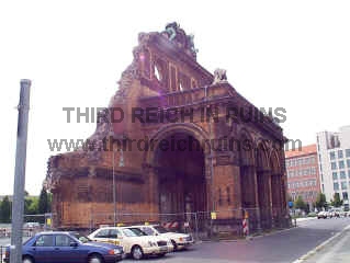
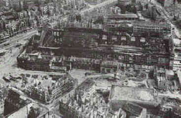
The Anhalter Bahnhof (train station) was severely damaged by bombing during the war, and the ruins were pulled down in the 1960s, leaving only part of the front façade. Right - the ruined Anhalter Bahnhof at the end of the war. The rectangular building at lower right is a massive concrete air-raid shelter. (Anhalter Bunker Museum)
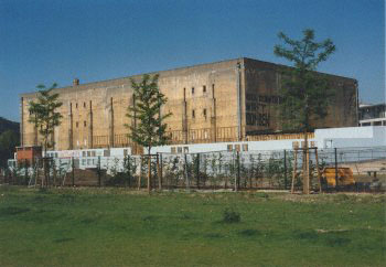
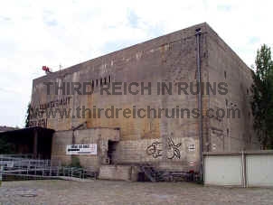
The Anhalter Bahnhof air-raid shelter, seen from the side closest to the Bahnhof. (Anhalter Bunker Museum) The Anhalter Bahnhof air-raid shelter serves today as a haunted house and bunker museum. (My advice if you visit - skip the "haunted house," and proceed directly to the bunker museum on the lower floor.)
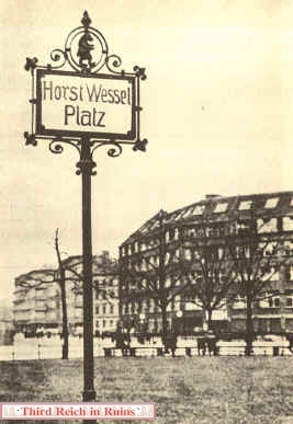
Horst Wessel was a member of the SA who was murdered by Communists in 1930. Propaganda Minister Joseph Goebbels turned him into a Nazi martyr and hero, and Wessel's song "Die Fahne Hoch!" became the favorite Nazi marching song. After the Nazi takeover of the government in 1933, Bülowplatz was renamed Horst Wessel Platz, and the Communists were thrown out of their headquarters at the Karl Liebknecht Haus, which became SA headquarters and a shrine to Horst Wessel. (Click here to see the site of Wessel's grave in the nearby Nikolaifriedhof cemetery.) (period photo from Imre Lazar, "Der Fall Horst Wessel," Stuttgart, 1980)
-
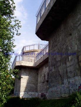
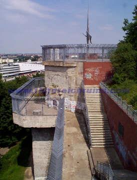
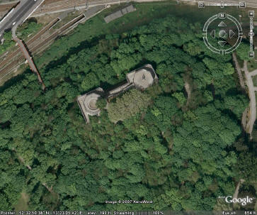
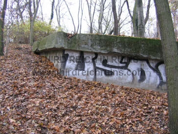
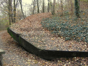
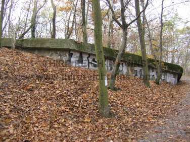
Berlin was protected by concentrated anti-aircraft defenses, including three huge concrete flak towers. Flakturm 1 in the Tiergarten was completely destroyed after the war. The massive concrete walls of the front half of Flakturm 3 remain in Humbolthain Park. (The metal railings are not period.) The main gun positions at each corner were for long-range 12.8cm flak guns; the smaller pedestals below were for smaller caliber guns of shorter range. The aerial view on the right, from Google Earth, shows the remains of the Humbolthain flak tower. (MapQuest Map Link)
Flakturm 2 was located in Friedrichshain Park. Following the war it was mostly destroyed and buried in rubble from the bombed city. Today only a small part of one of the upper parapets can be seen above ground. (Bundesarchiv Berlin) (MapQuest Map Link)
Click here to visit a page with more info and photos of the Berlin flak towers (in German).
Berlin, Part 2 Site of Hitler's Death and Burial, and other area sites
With the Soviet Army closing in, Hitler reportedly committed suicide in his bunker below the garden of the Reichs Chancellery on 30 April 1945.
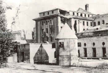
This view shows the emergency exit to the bunker (the low square concrete block, left of center), outside the entrance of which the bodies of Hitler and his wife Eva Braun were reportedly cremated and buried.
The conical tower was an armored ventilation and guard tower. The Führerbunker was underground, in the area behind and beneath the emergency exit and the conical tower.
The earlier Vorbunker was under the dining hall of the Old Chancellery, the low white building in the right rear.
(Bundesarchiv Berlin)
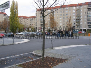
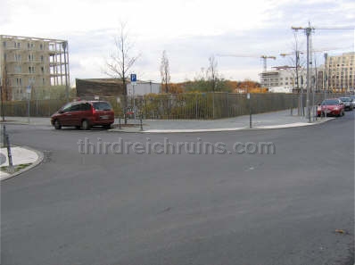
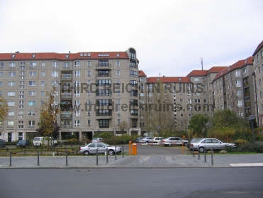
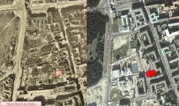
The area of the Reichskanzlei has been completely changed. It was in East Berlin, and the Communist government razed the ruins and leveled the area, which was near the Berlin Wall. However, the bunkers remained underground. But in 1988-89, apartment buildings were built on the site of the Chancellery and along Wilhelmstraكe, and the bunkers were destroyed in the process. The roof of the Führerbunker, which was reinforced concrete some 10 feet thick, was broken up and allowed to fall down into the rooms below, and the remains recovered. These remains are now under a parking lot near the angle in the 1988 street named An der Kolonnade, which runs between Wilhelmstraكe and Voss-Straكe. (This view is looking toward the apartment buildings along Wilhelmstraكe from the end of In der Ministergنrten Straكe, approximately the same angle as the period view to the left. The bunker remains are beneath the parking area at the right side of the photo, beneath and beyond where the tour group is standing, and the emergency exit was a little to the left of the center of the street intersection.)
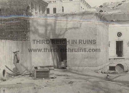
Previously unpublished photo of the Führerbunker emergency exit, probably taken in 1946. The Hitler bodies were cremated in the immediate right foreground. (courtesy James D. Bass, Jr.)
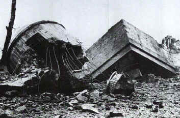
View from the opposite angle, showing the collapsed conical tower and emergency exit block, after demolition by the Soviets in 1947. (AP photo)
This area is now at the intersection of Gertrud-Kolmar-Straكe and In der Ministergنrten. The emergency exit would have been at the right edge of the photo. The Hitler and Goebbels bodies were burned just to the left.
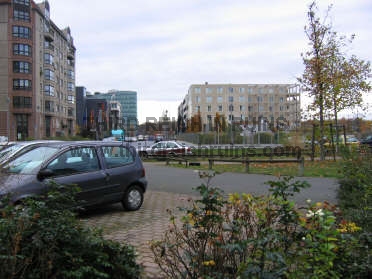
More modern views of the site (taken in 2005). The view on the left looks over the bunker site from the west, toward the Wilhelmstraكe apartment buildings (see map below). The main part of the bunker site is between the street in the foreground and the building in the background. The photo on the right is a view from the opposite side, looking 180 degrees back. The remains of the Führerbunker are beneath this parking area, street, and grassy area. The street going straight into the distance (toward Ebertstraكe) is a recent street called In der Ministergنrten.
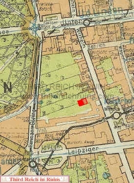
These maps of central Berlin show the location of the Führerbunker site (in red). The map on the left is part of a 1939 Berlin city atlas (Berliner Morgenpost - "Berlin in der Tasche") - the Führerbunker is shown behind and partly beneath the old Reichs Chancellery building (the Vorbunker was beneath the dining hall in the rear of the building). The modern street map on the right shows this same location, now behind the 1988-89 apartment buildings on Wilhelmstraكe (outlined in blue). The site is behind the apartments/businesses at Wilhelmstraكe 90-92, beneath a paved parking area and adjacent grassy area. Some guides and web pages say the remains are under a playground, but that is incorrect - the actual location is farther out from the buildings than the playground area. The site is at the end of the recent street called In der Ministergنrten (not shown on this map). (1939 map in author's collection)
These comparison aerial photos from 1945 (left) and 2003 (right) show the Führerbunker site in red. The 1945 photo shows the dining hall of the Old Chancellery (outlined on the right), beneath which was the Vorbunker, and the Führerbunker site just to the left, with the emergency exit and ventilation tower outlined at the left edge.

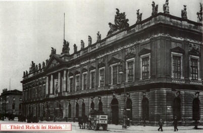
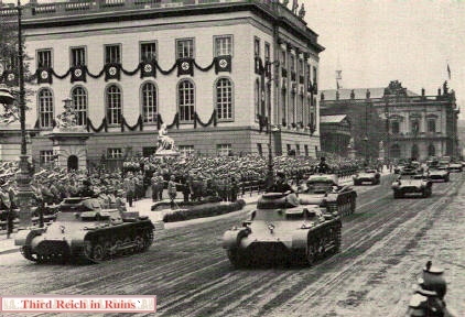 German Pzkw. I tanks parade down Unter den Linden during a visit by Admiral Miklَs Horthy, leader of Hungary, on 25 August 1938. The Neue Wache and the Zeughaus can be seen in the right background. (Gerd Rühle, ed., "Das Dritte Reich," Berlin, 1938 ed.)
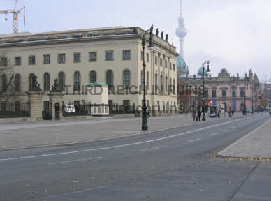
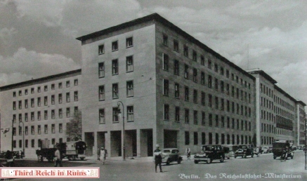
 View of the Luftfahrtsministerium at the corner of Wilhelmstraكe and Prinz-Albrecht-Straكe (Niederkirchnerstraكe today). (from Hubert Schrade, "Bauten des Dritten Reiches," Leipzig, 1937)