
DoD) operations)
DMSP, originally known as the Defense System Applications Program (DSAP) and the Defense Acquisition and Processing Program (DAPP), is a long-term USAF effort in space to monitor the meteorological, oceanographic and solar-geophysical environment of the Earth in support of DoD operations. All spacecraft launched have had a tactical (direct readout) and a strategic (stored data) capacity. In December 1972, DMSP data was declassified and made available to the civil/scientific community. The USAF maintains an operational constellation of two near-polar, sun-synchronous satellites. The DMSP mission is to provide global visible and infrared cloud data and other specialized meteorological, oceanographic and solar-geophysical data in support of world wide Department of Defense
DMSP satellite command and control is performed by the 6th Satellite Operations Group at Offutt AFB, Nebraska. Data is transmitted in real time to tactical terminals world-wide. Data is also stored using on-board recorders for transmission to and processing by the Air Force Global Weather Central (AFGWC), Offutt AFB, Nebraska and the Fleet Numerical Meteorology and Oceanography Center (FNMOC), Monterey, California. Both AFGWC and FNMOC relay the SSM/I, SSM/T and SSM/T2 data to the National Environmental Satellite, Data, and Information System (NESDIS). AFGWC also sends the entire data stream to the National Geophysical Data Center (NGDC).
Meteorological satellites developed and operated by the Air Force under the Defense Meteorological Satellite Program (DMSP). This program, previously known as DAPP (Data Acquisition and Processing Program), was classified until March 1973. The objective of this program is to provide global visual and infrared cloudcover data and specialized environmental data to support Department of Defense operational weather analysis and forecasting requirements. Operationally, the program consists of two satellites in sun-synchronous polar orbits, with the ascending node of one satellite in early morning and the other at local noon.
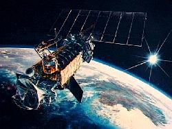
The 6.4-m-long spacecraft is separated into four sections: (1) a precision mounting platform for sensors and equipment requiring precise alignment; (2) an equipment support module containing the electronics, reaction wheels, and some meteorological sensors; (3) a reaction control equipment support structure containing the third-stage rocket motor and supporting the ascent phase reaction control equipment; and (4) a 9.29-sq-m solar cell panel. The spacecraft stabilization is controlled by a combination flywheel and magnetic control coil system so that sensors are maintained in the desired earth-looking mode. One feature is the precision-pointing accuracy of the primary imager to 0.01 deg provided by a star sensor and an updated ephemeris navigation system. This allows automatic geographical mapping of the digital imagery to the nearest picture element. The operational linescan system is the primary data acquisition system that provides real-time or stored, multi-orbit, day-and-night, visual and infrared imagery of clouds. A supplementary sensor package contains five special sensors: (1) a microwave temperature sounder, (2) an X-ray spectrometer, (3) an ionospheric/scintillation monitor, (4) a precipitating electron/ion spectrometer, and (5) a microwave imager. A magnetometer may also be included on this spacecraft. Either recorded or real-time data are transmitted to ground-receiving sites by two redundant S-band transmitters. Recorded data are read out to tracking sites located at Fairchild AFB, Washington, and at Loring AFB, Maine, and relayed by SATCOM to Air Force Global Weather Central, Offutt AFB, Nebraska. Real-time data are read out at mobile tactical sites located around the world.
ليس لديك تصريح لمشاهدة الرابط، فضلا قم ب تسجيل الدخول او تسجيل