
September 24, 2014
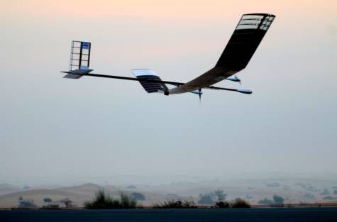
The super-craft termed High Altitude Pseudo Satellite (HAPS) has the ability to fly non-stop for more than two weeks and can shoot full HD videos.
UAE engineers along with Airbus Defence and Space have helped develop an unmanned super-craft that can fly in the stratosphere at a height of 65,600 feet (20km), Emirates Institute of Advanced Science and Technology (EIAST) has announced.
Dubai launches unmanned super-craft
Jointly developed by Airbus and Dubai-based EIAST, pseudo satellite creates regional record for highest flight
UAE engineers, along with Airbus Defence and Space, have helped develop an unmanned super-craft that can fly in the stratosphere at a height of 65,600 feet (20km), the Emirates Institute of Advanced Science and Technology (EIAST) has announced.
The super-craft termed High Altitude Pseudo Satellite (HAPS) has the ability to fly non-stop for more than two weeks and can shoot full HD videos.
The HAPS can be a handy tool for intelligence, surveillance and reconnaissance missions, while it can also be used for thermal imaging, creating temporary communications networks and strengthening navigation systems.
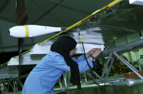
The joint operation between EIAST and Airbus DS had five Emirati engineers working on the prestigious projects alongside Airbus DS scientists to create the unique Unmanned Aerial System (UAS).
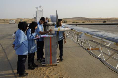
The first solar-powered HAPS was launched into the stratosphere on September 11 from EIAST’s Margham base in Dubai.
“The test flight lasted 23 hours and 47 minutes and reached a record altitude of 61,500 feet (18km) and successfully landed back in Dubai on September 12. It was a smooth flight and we were able to shoot some videos as well. This is now the highest recorded altitude for any flight in the region,” said Sara Yousuf Al Ameri, Advanced Aerial Systems Programme Manager at EIAST, as she presented the aircraft to the press.
In the first phase, the carbon-fibre built aircraft that weighs 34kg, will be used for testing and demonstrative purposes only.
“We started working on this project with Airbus DS to prepare a demonstration model of HAPS and by August the system was being assembled and tested in Dubai for a flight in September,” said Amal Abdullah, an avionics engineer and one of the five Emiratis who worked on the project.
The super-craft that has a wingspan of 18 metres and a length of seven metres is equipped with a payload of a high resolution video camera that can shoot from the altitude of 65,000 feet and focus on an object as small as 10cm in length. The full HD camera has the capability to zoom up to 30 times.
“Frankly speaking, the camera we have used is just like any other ordinary camera, but we opened it up and added our systems and enhanced it with a bit of technology and made it capable of what it does today. It can shoot full HD videos of almost all objects on earth,” explained Amal.
She added the HAPS fills a capability gap between satellites and UAS and among its key features is its ability to focus on a specific area of interest, which can be hundreds of miles wide, which satellites can’t do, while also providing it with satellite-like communications.
Operated by two independent motors, the HAPS has an ability to fly on its own for over two weeks, 10 times longer than any other Unmanned Aerial System (UAS) and offer intelligence, surveillance and reconnaissance services over long periods of time without interruption.
In the next phase, which will be completed in 2016, EIAST plans to build the next generation of HAPS in collaboration with Airbus DS that will be much more advanced.
“EIAST will design and manufacture parts of the next generation system in Dubai with the help of Airbus DS,” said Sara.
The super-craft termed High Altitude Pseudo Satellite (HAPS) has the ability to fly non-stop for more than two weeks and can shoot full HD videos.
UAE engineers along with Airbus Defence and Space have helped develop an unmanned super-craft that can fly in the stratosphere at a height of 65,600 feet (20km), Emirates Institute of Advanced Science and Technology (EIAST) has announced.
Dubai launches unmanned super-craft
Jointly developed by Airbus and Dubai-based EIAST, pseudo satellite creates regional record for highest flight
UAE engineers, along with Airbus Defence and Space, have helped develop an unmanned super-craft that can fly in the stratosphere at a height of 65,600 feet (20km), the Emirates Institute of Advanced Science and Technology (EIAST) has announced.
The super-craft termed High Altitude Pseudo Satellite (HAPS) has the ability to fly non-stop for more than two weeks and can shoot full HD videos.
The HAPS can be a handy tool for intelligence, surveillance and reconnaissance missions, while it can also be used for thermal imaging, creating temporary communications networks and strengthening navigation systems.
The joint operation between EIAST and Airbus DS had five Emirati engineers working on the prestigious projects alongside Airbus DS scientists to create the unique Unmanned Aerial System (UAS).
The first solar-powered HAPS was launched into the stratosphere on September 11 from EIAST’s Margham base in Dubai.
“The test flight lasted 23 hours and 47 minutes and reached a record altitude of 61,500 feet (18km) and successfully landed back in Dubai on September 12. It was a smooth flight and we were able to shoot some videos as well. This is now the highest recorded altitude for any flight in the region,” said Sara Yousuf Al Ameri, Advanced Aerial Systems Programme Manager at EIAST, as she presented the aircraft to the press.
In the first phase, the carbon-fibre built aircraft that weighs 34kg, will be used for testing and demonstrative purposes only.
“We started working on this project with Airbus DS to prepare a demonstration model of HAPS and by August the system was being assembled and tested in Dubai for a flight in September,” said Amal Abdullah, an avionics engineer and one of the five Emiratis who worked on the project.
The super-craft that has a wingspan of 18 metres and a length of seven metres is equipped with a payload of a high resolution video camera that can shoot from the altitude of 65,000 feet and focus on an object as small as 10cm in length. The full HD camera has the capability to zoom up to 30 times.
“Frankly speaking, the camera we have used is just like any other ordinary camera, but we opened it up and added our systems and enhanced it with a bit of technology and made it capable of what it does today. It can shoot full HD videos of almost all objects on earth,” explained Amal.
She added the HAPS fills a capability gap between satellites and UAS and among its key features is its ability to focus on a specific area of interest, which can be hundreds of miles wide, which satellites can’t do, while also providing it with satellite-like communications.
Operated by two independent motors, the HAPS has an ability to fly on its own for over two weeks, 10 times longer than any other Unmanned Aerial System (UAS) and offer intelligence, surveillance and reconnaissance services over long periods of time without interruption.
In the next phase, which will be completed in 2016, EIAST plans to build the next generation of HAPS in collaboration with Airbus DS that will be much more advanced.
“EIAST will design and manufacture parts of the next generation system in Dubai with the help of Airbus DS,” said Sara.
ليس لديك تصريح لمشاهدة الرابط، فضلا قم ب تسجيل الدخول او تسجيل
Source:
ليس لديك تصريح لمشاهدة الرابط، فضلا قم ب تسجيل الدخول او تسجيل